Difference between revisions of "Kings Weston Footbridge"
| Line 6: | Line 6: | ||
over Kings Weston Road (B4057), at the southern end near its junction with Shirehampton Road (B4054), Bristol | over Kings Weston Road (B4057), at the southern end near its junction with Shirehampton Road (B4054), Bristol | ||
This cast iron footbridge | NOTE: The bridge was badly damaged in 2015 by being struck by a lorry, and currently (January 2022) remains unrepaired. | ||
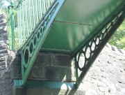
This cast iron footbridge connected the former estates, now public parks, of Kings Weston House and Blaise Castle. Latterly it was used as a safe crossing over a dangerous road. | |||
Believed to have been built c.1820 (between 1819 and 1821, when a new road was cut through the estate by [[John Loudon McAdam]]<ref>[http://www.bristol.gov.uk/sites/default/files/documents/leisure_and_culture/parks_and_open_spaces/Kings%20Weston%20CMP%20v1.0%20part%201%20of%203.pdf] Bristol City Council/Historic Design Group - Kings Weston Estate: Historic Landscape Conservation Management Plan. Note: Large PDF</ref>. | Believed to have been built c.1820 (between 1819 and 1821, when a new road was cut through the estate by [[John Loudon McAdam]]<ref>[http://www.bristol.gov.uk/sites/default/files/documents/leisure_and_culture/parks_and_open_spaces/Kings%20Weston%20CMP%20v1.0%20part%201%20of%203.pdf] Bristol City Council/Historic Design Group - Kings Weston Estate: Historic Landscape Conservation Management Plan. Note: Large PDF</ref>. | ||
Revision as of 09:49, 14 January 2022
over Kings Weston Road (B4057), at the southern end near its junction with Shirehampton Road (B4054), Bristol
NOTE: The bridge was badly damaged in 2015 by being struck by a lorry, and currently (January 2022) remains unrepaired.
This cast iron footbridge connected the former estates, now public parks, of Kings Weston House and Blaise Castle. Latterly it was used as a safe crossing over a dangerous road.
Believed to have been built c.1820 (between 1819 and 1821, when a new road was cut through the estate by John Loudon McAdam[1].
In general appearance it resembles a number of other parkland footbridges from the early 1800s. However, the half arch members were cast in a closed mould, rather than the more common and inferior method of casting in an open mould. This allowed the use of 'I' section arch members, although the flanges are of very modest width.
The slender vertical railings between the more substantial ones appear to be relatively recent additions, being welded to the original railings.


